| Paturau River | |
|---|---|
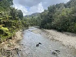 Paturau River as seen from the abandoned bridge | |
| Location | |
| Country | New Zealand |
| Physical characteristics | |
| Source | |
| • location | Wakamarama Range |
| • elevation | 1,110 metres (3,640 ft) |
| Mouth | |
• location | Tasman Sea |
• elevation | 0 m (0 ft) |
| Length | 25 kilometres (16 mi) |
The Paturau River (sometimes spelt Patarau) is a river of the Tasman Region of New Zealand's South Island.[1] One of the northernmost rivers in the South Island, it flows predominantly north from its sources in the Wakamarama Range to reach the Tasman Sea 20 kilometres west of Collingwood.[2]
See also
References
- ↑ "Place name detail: Paturau River". New Zealand Gazetteer. New Zealand Geographic Board. Retrieved 12 July 2009.
- ↑ New Zealand 1:50000 Topographic Map Series sheet BN23 – Paturau River
40°39′S 172°26′E / 40.650°S 172.433°E
This article is issued from Wikipedia. The text is licensed under Creative Commons - Attribution - Sharealike. Additional terms may apply for the media files.